
Social Distancing on Thunder Mountain
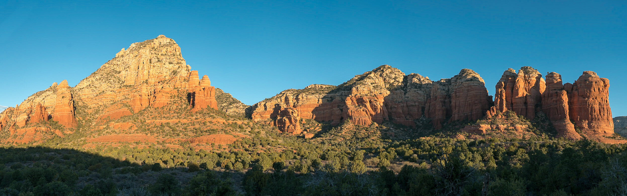
ol’ Greyback viewed from the Thunder Mountain trail
“It’s the end of the world as we know it”
That song keeps racing through my mind. As the world changes exponentially in front of our eyes, I’m stuck thinking linearly - like most other humans. I’m down in the high desert of Arizona, in the peace and tranquility of a yoga ‘chakras’ intensive. I’m just a peripheral player - my sister-in-law, Shraddha, is the owner of Sedona’s oldest yoga arts program, 7 Centers Yoga Arts. The beautiful facility sits perched on the edge of Airport Mesa and has a commanding view of a big pile of rock called Thunder Mountain. I’ve been looking at this rock for a long time - over 15 years. Over that time I’ve also hiked around its edges - Coffeepot trail, Amitabh Pagoda, Chimney Rock, Dry Creek, Devil’s Bridge, Soldier’s Pass, Bear Mountain, and Brin Mesa. I’ve seen the mountain from a number of angles: Rain, snow, clouds. Close, far, from the north, from the south.


7 mile loop and oops
Thinking Linearly
I’ve done a few trail runs along the south side of Thunder Mountain - a basic 5-mile loop out from the house up to Coffeepot Rock and back. Twice I’ve gotten myself in trouble on these runs; once by over-exerting before getting acclimated (the elevation is 4500 ft) and another time - on the same trail - I slipped and careened into a big boulder, resulting in a rib contusion. Still, I would much prefer to run on trails than on streets.
So last week we escaped Seattle to visit Sedona in the midst of the Covid-19 pandemic, the Sedona Film Festival, the Sedona Mountain Biking Festival, and two yoga teacher’s immersions at 7Centers. I was feeling energetic, adventurous, and yes a bit stupid so I tried out a slightly longer 7-mile loop along Thunder Mountain trail then over Chimney Rock and out towards Lizard Head, at which point I promptly got lost and had to bushwhack along the rocky edge of Thunder Mountain, reversing across ledges then scree then sage and mesquite before finding the trail again further down. GPS is definitely not reliable; if you start a route mapping app and just stand still, the line will move on its own accord! But I got back in one piece, well-rested, and ready for “something more.” Ever done that?
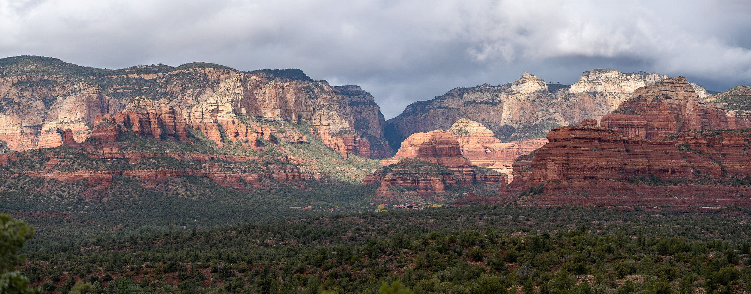
Thunder mountain is flanked by…


A Tour de Thunder Mountain: Why Not?
12 mile loop around Thunder Mountain, aka Capitol Butte, aka old Greyback.
So looking at the maps, it occurred to me that I could probably do a trail run all the way around the mountain, affording a vista from all sides. I figured, if I got tired, I would just head back. And worst case, I could call Fran and ask her to pick me up. Right? So off I went, up along Posse Ground past several hundred festive mountain bikers to upper Sunset Trail, under the spout of Coffeepot, and up along Soldier Pass trail. At the three-mile point, right by the 7 Heavenly Pools, I stopped for a reality check. Feeling good? Yup. Heart rate in the 140s, not tired. I continued up the trail as it wound upwards towards Soldier Pass.


Quickly both my legs and my Apple Watch said, “better to walk” so that’s exactly what I did, ambling over the top of the pass at a comfortable gait. No ego here, just enjoying the view. From there, it was several miles of gradual downhill and wonderful views of the red rocks and the back side of Thunder Mountain. It was one of the most pleasureful long runs I’ve ever done and the only damage was a couple of purple toes.


To See What He Could See
I felt really good when I got back two hours later. I found myself looking at that map again. Maps and I, when together, have a history of doing dumb things. Once a few years back, I traced the longest stretch of railroad track on earth - from Singapore to Narvik, Norway - so of course, I just had to take the train. It took two months and 30 trains to make the journey.
This was a bit less. The map showed a trail to the top of Thunder Mountain, roughly following the southwest ridge. I asked a few locals who had walked up it. “Stay on the trail and you’ll be ok” was the common advice, “but if you stray from the route, you could get into trouble quickly.” So I read a few reviews about the route. “It’s not well marked but you can follow the cairns built by others.” “If you can’t see the next cairn, turn back. You’re off the trail.” And “Although it has exposed views and can be steep in points, at no point will you ever feel as if you need a rope.”
I definitely wanted to head up the trail “to see what I could see,” but my priority was just to take photos at sunrise. I was not committed to actually climbing the big rock - or so I told myself. Stupidly, I thought it would be smart not to invite another person to accompany me because I wanted to be able to turn around at any point if I felt uncomfortable with the terrain; I did not want to deal with someone else’s ego. Likewise, I also did not want to deal with someone’s fears, should I feel both safe, and inspired, to continue upwards. Two very stupid reasons to venture out on one’s own. And here’s a third one: there should be other people on the trail, and I’ve got cell service. So no problem, right?
A Short Walk At Sunrise
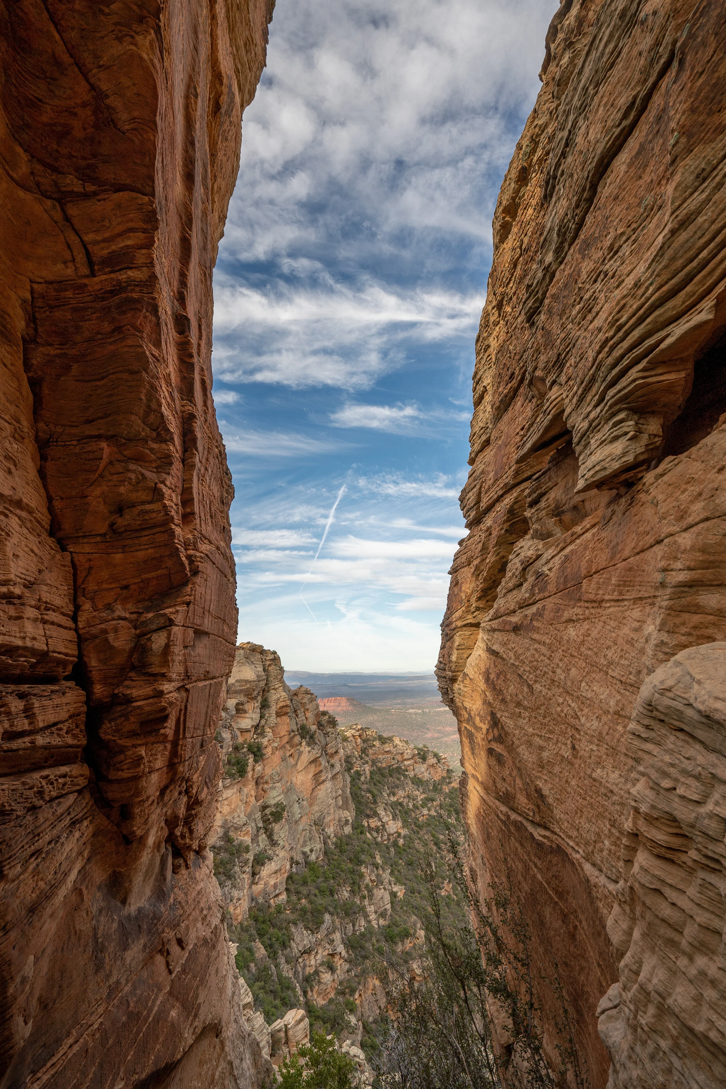
So. No ego. Just going up for the photos. Turn around at any time. Off I went, at 6:30 am, my pack filled with two cameras, three lenses, and one water bottle. It was a beautiful, calm morning. A well-marked trail wound its way up the southwest flank of the mountain through the scrub, up to a ridge with views looking down both sides:


From there, the trail became more of a scramble. It steepened and followed the ridge right up the west flank. At more than one point, it traversed out across the front face with some exposed views out over the city but I realized that if I were to actually take a tumble, I would slide no more than a five feet. Or so. (The chances of me taking a tumble were very low; at any steep or exposed part, I actually hugged the mountainside on all fours and probably looked, literally, like a scaredy cat stuck up a tree.) So I continued up. The route was well marked with cairns on rocks, and shoe prints appeared wherever there were sections of trail, a kind of late confirmation that I wasn’t lost. The only really steep sections were in tight chimneys where it was actually easy to work my way up. So on I went, snapping pictures along the way. And then suddenly, before I knew it, I popped out on top of the big rock, and there was the view. Out there, all around.
As I sat on that big flat rock on top of Thunder Mountain, all of Arizona seemed splayed out below. It was so quiet down there, just the distant hum of Pink Jeeps carting tourists around to see the vortexes and other points of interest.
I felt socially distant from it all. Then it occurred to me why I felt that: the term “social distancing” had just been introduced to us through the social and mainstream media. What the heck does that mean? I pondered it for a nanosecond, then grabbed my pack and began to pick my way back down the mountain. Now let’s see, which way was that?


Getting Down
I promise I didn’t wander around as much as this GPS recording suggests!
Down is not always faster than up. For starters, somehow the markers that I saw on the way up, appeared different on the way down. Some disappeared entirely, or so it seemed. It was quite easy to get off the ‘trail’ and I managed to do that almost as soon as I set off from the summit. Most alarming was that the top is relatively flat and appears to be friendly and rounded. But it quickly drops off, preciptously and in a convex manner, in all directions. So it is rather important to know the one route down. I immediately missed it and found myself wandering along a non-trail that kind of emptied out into space. I hastily backtracked and recovered the route. GPS was not particulalry helpful because the up-route that appeared on my map did not really match the downroute due to the cell towers constantly re-calculating the triangulations.
A Lesson in Logarithmic Thinking
We arrived back in Seattle a couple of days later, last week. The flight was eerily empty, as were both airports. Back in our own neighborhood - West Seattle - we took a short walk down to Alki Beach and back up. We could see people in restaurants. We talked about which restaurant we had missed the most, and where we should go first. Two days later, everything was closed. A day after that, everyone was standing six feet apart even in the grocery store lines. And yes, toilet paper was sold out everywhere. Just like that. Life has changed, probably for a very long time, maybe forever: from a higher level, this pandemic is just another salvo from mother nature, a kind of karmic observation (not judgement!) of our misguided ways. The planet is over-populated so these kinds of pandemics will continue. Unfettered growth is not sustainable, at least in the world as we knew it. And we’ve forced climate change upon ourselves. And there is a large segment of our population that denies it all. Ironically, carbon emissions have plummeted globally over the past few weeks. Isn’t it interesting, that a tiny little virus can get us to do what nobody else could? I like to call it a lesson in logarithmic thinking.
It will remain to be seen what lasting effects the Covid-19 pandemic has on the way we live and on how we perceive our short sojourns on this planet. But at least I have the memories of a time when things were delightfully linear.